 By Saurav Mehra
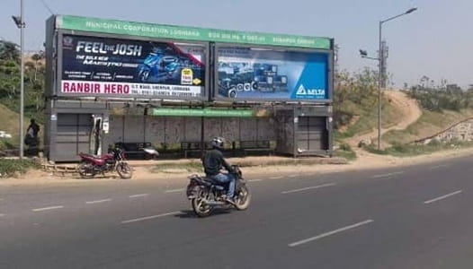
 Sherpur Chowk, Ludhiana is one of the most strategically positioned and commercially significant urban intersections in Punjab’s largest and most industrially productive city, serving as a primary daily transit and commercial reference point for the large residential and working population of the Sherpur locality and the broader northern Ludhiana belt. Located along one of the city’s important arterial road corridors, this chowk has developed into a genuinely busy neighbourhood hub whose daily activity reflects the working-class commercial energy and the entrepreneurial spirit that defines Ludhiana’s character as India’s most productive manufacturing city — a place that makes bicycles, hosiery, machine tools, and auto components at a scale that shapes markets globally while sustaining a very large and economically active local population.
Ludhiana’s growth has been organic, industrial, and relentless, and the neighbourhoods that have developed around its manufacturing economy carry that character in their street-level commercial life. Sherpur Chowk serves a population whose daily needs are practical and immediate — affordable groceries, reliable transport connections, accessible medical care, good schools for their children, and the kind of neighbourhood market ecosystem that makes urban industrial life workable for working and middle-class families. The chowk is surrounded by this kind of honest, functional commercial infrastructure whose vitality comes from genuine community need rather than curated lifestyle positioning. For the traders, factory workers, government employees, and families whose daily lives converge at this intersection, Sherpur Chowk is an indispensable daily constant around which neighbourhood life organises itself with the reliability that long-established community commercial spaces provide.
| Detail | Information |
| Location | Sherpur Chowk, Ludhiana, Punjab |
| Type of Junction | Neighbourhood Commercial Intersection / Industrial Residential Hub |
| Primary Road | Sherpur Road / Ludhiana Arterial Connector |
| Nearest Railway Station | Ludhiana Junction Railway Station — Approx. 6–8 km |
| Nearest Airport | Sahnewal Airport (Ludhiana) — Approx. 8–10 km |
| Key Roads Connected | Sherpur Road, Ferozepur Road, Pakhowal Road, Haibowal Road |
| Distance from Ludhiana City Centre | Approx. 5–7 km |
| Distance from Chandigarh | Approx. 95 km via NH-95 |
| Distance from Jalandhar | Approx. 80 km via GT Road |
| Distance from Delhi | Approx. 310 km via NH-44 |
| Governing Authority | Ludhiana Municipal Corporation, Punjab PWD |
| Nearby Landmarks | Sherpur Village, Haibowal Dairy Complex, Ferozepur Road Industrial Belt |
| Public Transport Options | PUNBUS, City Bus, App Cabs, Auto-Rickshaw |
| Best Suited For | Northern Ludhiana residential and industrial corridor daily traffic |
| Peak Traffic Hours | 8:30 AM – 11:00 AM and 5:00 PM – 8:30 PM |
Location of Sherpur Chowk
Sherpur Chowk is geographically positioned in the Sherpur area of northern Ludhiana, at the junction of Sherpur Road and the connecting arterials that link this residential and semi-industrial locality to the broader Ludhiana road network. The chowk takes its name from the Sherpur village community that has been a permanent feature of this landscape through the city’s industrial expansion, and the junction sits at the transitional zone between the established urban fabric of Ludhiana’s northern residential belt and the semi-urban character of the areas approaching the city’s periphery. The Ferozepur Road industrial corridor — one of Ludhiana’s most important manufacturing belts — is directly accessible from the Sherpur Chowk zone, giving the junction a significant industrial workforce transit function alongside its neighbourhood commercial role.
Directions to Sherpur Chowk
From Ludhiana Junction Railway Station: Exit the station and travel northwestward via the city’s main arterials heading toward the northern residential and industrial belt. Continue through the city’s commercial zones toward the Sherpur area. Sherpur Chowk is approximately 6 to 8 kilometres from the station with a travel time of 20 to 35 minutes through Ludhiana’s moderately congested urban road network.
From Sahnewal Airport: Exit the airport and connect to the airport approach road heading toward the city. Continue northward along the connecting arterials toward the Sherpur zone. Total distance from the airport is approximately 8 to 10 kilometres with a travel time of 20 to 30 minutes.
From Chandigarh via NH-95: Travel southwestward from Chandigarh along NH-95 heading toward Ludhiana. Continue approximately 95 kilometres through the Punjab highway corridor. Enter Ludhiana from the eastern approach and head toward the northern zone where Sherpur Chowk is located. Travel time is approximately 90 to 120 minutes.
From Ferozepur Road Industrial Belt: Travel northward from the Ferozepur Road manufacturing zone via the connecting arterials heading toward the Sherpur residential belt. Sherpur Chowk is accessible within the northern residential zone approximately 5 to 7 kilometres from the industrial estate’s main commercial zone with a travel time of 15 to 25 minutes.
From Jalandhar via GT Road: Travel southwestward from Jalandhar along GT Road (NH-44) heading toward Ludhiana. Continue approximately 80 kilometres through the central Punjab agricultural and industrial corridor. Enter Ludhiana and head toward the northern zone. Travel time is approximately 90 to 110 minutes.
Public Transport Connectivity
Ludhiana does not currently have an operational metro rail system, and the city’s public transport infrastructure relies on PUNBUS intercity services, private bus operators, and city-level transport for daily mobility. PUNBUS operates comprehensive services from Ludhiana’s main bus stand connecting the city to Chandigarh, Jalandhar, Amritsar, Patiala, and Delhi. City bus services serve multiple routes through the northern Ludhiana arterials connecting Sherpur Chowk to the railway station, the bus stand, and the city’s major commercial and residential zones. Auto-rickshaws are the dominant intra-city short-trip mode throughout Ludhiana’s commercial and residential zones, operating extensively around the Sherpur Chowk area throughout the day. App-based cab services have seen strong adoption among Ludhiana’s professional and business population for longer journeys toward the airport, railway station, and city center.
Road Connectivity
- Sherpur Road provides the primary arterial connectivity through the Sherpur locality connecting the chowk to the broader northern Ludhiana road network.
- Ferozepur Road extends southward toward the Ferozepur Road industrial and commercial belt — one of Ludhiana’s most important manufacturing corridors.
- Pakhowal Road connects toward the Pakhowal residential zone and the southeastern Ludhiana corridor.
- Haibowal Road extends toward the Haibowal area — home to one of Punjab’s most important dairy processing complexes.
Nearby Areas and Neighbourhoods
Haibowal Dairy Complex: One of Punjab’s most important and largest dairy processing and distribution facilities, the Haibowal Dairy complex is located within the broader Sherpur Chowk catchment zone and represents a significant institutional and commercial anchor that draws dairy-related commercial traffic through the junction daily.
Ferozepur Road Industrial Zone: The important manufacturing belt along Ferozepur Road is directly accessible from Sherpur Chowk and houses textile mills, hosiery units, and light engineering workshops whose large workforce contributes substantially to the junction’s peak-hour industrial commuter traffic.
Sherpur Village Community: The original village that gives the chowk its name has been substantially absorbed into Ludhiana’s urban expansion while maintaining a distinct community identity, with its own religious spaces, local markets, and the close-knit social fabric of a Punjabi village community navigating urban transformation.
New Sherpur Residential Colonies: The planned residential developments that have grown up around the original Sherpur village community offer mid-segment housing for Ludhiana’s working and middle-class population, with improving civic infrastructure as the area continues urbanising within the municipal corporation’s development framework.
BRS Nagar Connector: The well-established BRS Nagar residential locality accessible from Sherpur Chowk via the connecting road network offers a more premium residential character within comfortable proximity of the junction, representing the residential diversity of this part of northern Ludhiana.
Frequently Asked Questions (FAQs)
Q1. Where is Sherpur Chowk located in Ludhiana?
Sherpur Chowk is in the Sherpur area of northern Ludhiana, Punjab, approximately 6 to 8 kilometres from Ludhiana Junction Railway Station.
Q2. How far is Sherpur Chowk from Chandigarh?
Chandigarh is approximately 95 kilometres from Sherpur Chowk via NH-95, with a travel time of 90 to 120 minutes.
Q3. Is there metro connectivity at Sherpur Chowk Ludhiana?
Ludhiana does not have an operational metro. PUNBUS, city buses, auto-rickshaws, and app-based cabs provide public transport coverage.
Q4. What industrial zones are near Sherpur Chowk?
The Ferozepur Road industrial belt and the Haibowal Dairy Complex are the most significant commercial and industrial facilities near Sherpur Chowk.
Q5. How far is Sherpur Chowk from Ludhiana Airport?
Sahnewal Airport is approximately 8 to 10 kilometres from Sherpur Chowk with a travel time of 20 to 30 minutes.