 By Saurav Mehra
 Darbhanga already has Tower Chowk carrying the city’s central commercial weight, but Azad Chowk holds its own distinct position in the city’s daily geography — a junction that serves a specific residential and commercial corridor with the quiet consistency of a neighbourhood landmark that does not need to compete for significance. Named after Chandra Shekhar Azad with the same post-independence civic sentiment that placed this name on junctions across North India, the chowk functions as a daily transit and commercial node for the population of one of Bihar’s most culturally rich district headquarters cities.
Darbhanga’s Mithila identity runs deep — the Madhubani painting tradition, the classical music heritage of the Darbhanga Gharana, and the architectural legacy of the Darbhanga Raj give this city a cultural sophistication that its modest infrastructure cannot always express outwardly. Azad Chowk serves the working daily life of this culturally layered city with the straightforward commercial functionality that working populations everywhere require — markets, transport connections, and the kind of neighbourhood commercial activity that sustains families across the economic spectrum of a Bihar district capital.
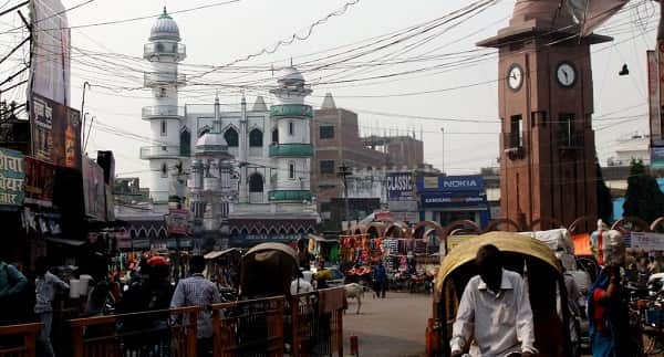
Azad Chowk, Darbhanga Overview
| Detail | Information |
| Location | Azad Chowk, Darbhanga, Bihar |
| Type of Junction | Neighbourhood Commercial Intersection |
| Primary Road | Azad Chowk Road / Darbhanga Internal Arterial |
| Nearest Railway Station | Darbhanga Railway Station — Approx. 3–5 km |
| Nearest Airport | Darbhanga Airport — Approx. 7–10 km |
| Key Roads Connected | Azad Road, Laheriasarai Road, Benta Road, Town Hall Road |
| Distance from Tower Chowk | Approx. 1–2 km |
| Distance from Laheriasarai | Approx. 3–4 km |
| Distance from Muzaffarpur | Approx. 70 km via NH-527 |
| Governing Authority | Darbhanga Municipal Corporation, Bihar PWD |
| Nearby Landmarks | Darbhanga Town Hall vicinity, Local Market, Laheriasarai Bridge zone |
| Public Transport Options | Bihar SRTC Bus, Shared Auto, App Cabs, Cycle Rickshaw |
| Peak Traffic Hours | 9:30 AM – 12:30 PM and 4:30 PM – 8:00 PM |
Location
Azad Chowk sits within Darbhanga’s central residential and commercial belt, at a junction connecting the city’s internal road network in the zone between Tower Chowk and the Laheriasarai bridge approach. The proximity to Tower Chowk — barely 1 to 2 kilometres — means the two junctions collectively form a commercial corridor rather than competing isolated nodes. Where Tower Chowk handles the city’s primary wholesale and major retail activity, Azad Chowk serves the daily residential neighbourhood needs of the surrounding mohallas with a slightly more intimate commercial character.
Directions
From Darbhanga Railway Station: Exit the station and travel toward the city’s central commercial zone via the station approach road. Azad Chowk is approximately 3 to 5 kilometres, 15 to 20 minutes by shared auto or cycle rickshaw through the central Darbhanga road network.
From Darbhanga Airport: Travel toward the city via the airport approach road and connect to the central zone. About 7 to 10 kilometres from the airport, 20 to 30 minutes by app cab.
From Tower Chowk: The two chowks are barely 1 to 2 kilometres apart on the same commercial corridor — a 5 to 10 minute journey by any mode.
From Laheriasarai: Cross the Balan River toward Darbhanga and head into the central commercial belt. Azad Chowk is approximately 3 to 4 kilometres from the Laheriasarai zone, 15 to 20 minutes.
From Muzaffarpur: Travel northeastward along NH-527 approximately 70 kilometres toward Darbhanga. Enter the city and head toward the central zone. Travel time is approximately 90 to 120 minutes.
Public Transport Connectivity
Bihar SRTC and private bus operators connect Darbhanga to Muzaffarpur, Patna, Sitamarhi, Madhubani, and other Bihar destinations from the main bus stand. Darbhanga Railway Station provides rail connectivity on the Samastipur-Darbhanga corridor with trains heading toward major destinations including Patna and Delhi. Darbhanga Airport’s recent reactivation has added air connectivity for the Mithilanchal region. Cycle rickshaws and shared autos handle intra-city movement — the cycle rickshaw remains genuinely practical in Darbhanga’s narrower market lanes where motorised vehicles struggle. App-based cabs are increasingly used for airport and station journeys.
Nearby Areas
Town Hall Area: Darbhanga’s civic administrative zone near the chowk contributes institutional traffic from government employees and citizens accessing municipal services, giving the junction’s morning commercial activity a specific government office-hour rhythm.
Laheriasarai Commercial Belt: The twin city across the Balan River is directly connected to the Azad Chowk zone and its population uses the central Darbhanga commercial corridor regularly, effectively extending the chowk’s commercial catchment across the river.
Darbhanga Medical College Hospital: One of North Bihar’s most important public healthcare facilities, accessible from the Azad Chowk zone, generating consistent medical visitor and staff traffic through this part of the city.
Old Residential Mohallas: The established residential neighborhoods surrounding the chowk house Darbhanga’s older trading families, government employees, and the middle-class community whose daily commercial patterns have sustained this junction’s market activity across generations.
Frequently Asked Questions (FAQs)
Q1. Where is Azad Chowk in Darbhanga?
A: Central Darbhanga, Bihar, approximately 3 to 5 kilometres from Darbhanga Railway Station and 1 to 2 kilometres from Tower Chowk.
Q2. How far is Darbhanga Airport from Azad Chowk?
A: About 7 to 10 kilometres, accessible in 20 to 30 minutes by road.
Q3. What public transport serves Azad Chowk Darbhanga?
A: Bihar SRTC buses, shared autos, cycle rickshaws, and app-based cabs.
Q4. How far is Azad Chowk from Tower Chowk Darbhanga?
A: About 1 to 2 kilometres — both junctions together form Darbhanga’s central commercial corridor.
Q5. How far is Darbhanga from Muzaffarpur?
A: Approximately 70 kilometres via NH-527, taking 90 to 120 minutes.