 By Saurav Mehra
 Rohini has enough internal geography to be a small city — 22 sectors, over a million residents, its own commercial strips, parks, schools, and the entire civic infrastructure of a functioning urban township that happens to sit within Delhi’s administrative boundary. Ayodhya Chowk in Rohini is one of the neighbourhood-level junctions that give this enormous township its internal navigational structure, serving a residential catchment whose daily commercial and transit needs are genuine and substantial even if the junction does not appear prominently in city-wide traffic discussions.
The name Ayodhya carries the same devotional weight here as it does elsewhere in North India — a name associated with Ram Janmabhoomi and one of Hinduism’s most sacred cities, chosen for the civic space of a planned colony that houses a predominantly North Indian residential population for whom this cultural association is naturally meaningful. The chowk functions with the practical efficiency of a well-located neighbourhood junction in a large residential township — busy during school and office hours, commercially active through the morning, and serving as the evening social space where colony life slows slightly and becomes more visible.
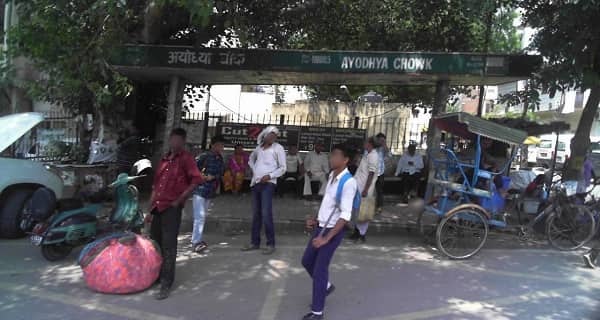
Ayodhya Chowk Overview
| Detail | Information |
| Location | Ayodhya Chowk, Rohini, North-West Delhi |
| Type of Junction | Neighbourhood Commercial Intersection |
| Primary Road | Rohini Sector Road / Internal Colony Arterial |
| Nearest Metro Station | Rohini East / Rohini West — Delhi Metro Red Line |
| Key Roads Connected | Rohini Sector Roads, Outer Ring Road Connector, GT Karnal Road Connector |
| Distance from Connaught Place | Approx. 17–20 km |
| Distance from Pitampura | Approx. 5–7 km |
| Distance from Mukarba Chowk | Approx. 4–6 km |
| Governing Authority | North Delhi Municipal Corporation, DDA, DMRC |
| Nearby Landmarks | Rohini Sector Markets, Nearby Schools and Dispensaries, Local Park |
| Public Transport Options | Delhi Metro Red Line, DTC Bus, Shared Auto, App Cabs |
| Peak Traffic Hours | 8:30 AM – 11:00 AM and 5:30 PM – 9:00 PM |
Location
Ayodhya Chowk sits within Rohini’s planned residential sector grid, at the intersection of sector roads that connect the surrounding residential blocks to each other and to the external arterials heading toward GT Karnal Road and the Outer Ring Road. The DDA’s planning framework for Rohini created a series of such neighbourhood-level junctions at regular intervals through the sector grid, each of which has developed its own commercial identity and community character over the three-plus decades since the township was built. Ayodhya Chowk’s specific character reflects the residential sectors it immediately serves — predominantly middle-class government employee and professional families whose daily commercial needs have attracted the typical Rohini neighbourhood market ecosystem of grocers, medical shops, coaching centres, and sweet shops.
Directions
From Connaught Place: The Red Line metro is the practical choice — board heading northward toward Rithala and exit at Rohini East or Rohini West. By road, travel northwestward via the Outer Ring Road through Ashok Vihar into the Rohini sector network. About 17 to 20 kilometres, 40 to 60 minutes by road.
From Pitampura: Head northward from Pitampura’s commercial zone via the Rohini sector connecting roads. Ayodhya Chowk is approximately 5 to 7 kilometres, 15 to 25 minutes through the residential colony road network.
From Mukarba Chowk: Travel westward from the Ring Road junction into the Rohini sector interior. About 4 to 6 kilometres, 15 to 20 minutes.
From Rohini East Metro Station: Exit the metro and navigate via the sector roads — shared autos connect the metro station to the sector interior junctions like Ayodhya Chowk throughout the day.
Metro and Public Transport Connectivity
Rohini East and Rohini West on the Red Line are the practical metro access points, with shared autos providing the last-mile connectivity into the sector interior where Ayodhya Chowk is positioned. The Red Line gives Rohini residents direct southward connectivity through Pitampura, Netaji Subhash Place, and eventually the interchange at Inderlok with the Green Line — making the full Delhi metro network accessible from this North-West residential township. DTC buses run through the major Rohini sector roads. Shared autos cover the interior sector routes that buses cannot efficiently navigate, running between the metro stations and the various sector commercial junctions throughout the day.
Nearby Areas
Rohini Residential Sectors: The sectors immediately surrounding Ayodhya Chowk form its primary residential catchment — DDA flats and plotted developments housing the government employees, traders, and working professionals whose daily commercial patterns sustain the chowk’s market activity.
AIIMS Rohini Campus: The new AIIMS facility in the Rohini belt adds an important institutional healthcare dimension to this part of the township, generating medical visitor and staff traffic that will increasingly influence the commercial character of surrounding junctions.
Rohini Sector Local Markets: Each Rohini sector has a designated commercial zone, and the markets around Ayodhya Chowk serve their local residential catchment with daily essentials at the price points that suit a large middle-class colony population.
Outer Ring Road Proximity: The Ring Road’s accessibility from the Rohini sector network makes the Ayodhya Chowk zone well-connected to the broader Delhi arterial system without the gridlock that more centrally located junctions face.
Frequently Asked Questions (FAQs)
Q1. Where is Ayodhya Chowk in Rohini Delhi?
A: Inside the Rohini planned residential township, North-West Delhi, approximately 17 to 20 kilometres from Connaught Place.
Q2. Which metro serves Ayodhya Chowk Rohini?
A: Rohini East and Rohini West on the Delhi Metro Red Line, with shared autos providing sector interior connectivity.
Q3. How far is Ayodhya Chowk Rohini from Pitampura?
A: About 5 to 7 kilometres via the Rohini connecting roads, 15 to 25 minutes.
Q4. What type of residential population surrounds Ayodhya Chowk?
A: Predominantly middle-class government employees, traders, and working professionals in DDA flats and plotted developments typical of Rohini’s planned colony character.
Q5. How far is Ayodhya Chowk Rohini from Mukarba Chowk?
A: Approximately 4 to 6 kilometres via the Ring Road and sector road connector.