 By Saurav Mehra
 Rajkot moves at a pace that outsiders often mistake for unhurried but is actually just efficient. This is a city that gets things done without the performative urgency of Mumbai or the bureaucratic lethargy of slower Indian cities — a Saurashtra commercial character that is direct, practical, and quietly confident. Ayodhya Chowk fits within that civic personality. Named with the devotional significance that the name Ayodhya carries across Hindu culture — the birthplace of Lord Ram and one of India’s most sacred cities — this junction in Rajkot’s commercial and residential belt has become a daily navigation reference for a city that organises its geography around a handful of key chowks whose names everyone knows.
Rajkot’s urban geography is relatively compact and navigable compared to Gujarat’s larger cities, and Ayodhya Chowk benefits from this — it sits within a commercial zone that is genuinely accessible from most parts of the city without the extended travel times that equivalent junctions in Ahmedabad or Surat demand. The surrounding area reflects the Rajkot commercial character — jewelry shops, textile establishments, the kind of wholesale and retail mix that a Saurashtra trading city generates naturally, alongside the residential colonies of the families who have built their lives around this productive commercial culture.
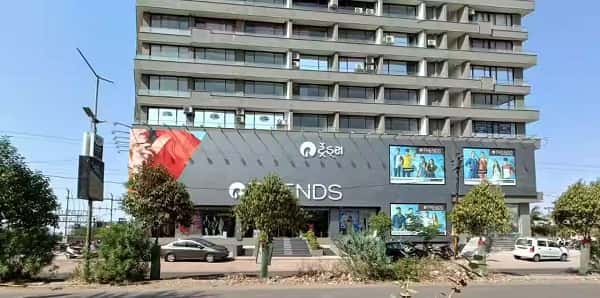
Ayodhya Chowk Overview
| Detail | Information |
| Location | Ayodhya Chowk, Rajkot, Gujarat |
| Type of Junction | Commercial Urban Intersection |
| Primary Road | Ayodhya Chowk Road / 150 Feet Ring Road |
| Nearest Railway Station | Rajkot Railway Station — Approx. 4–6 km |
| Nearest Airport | Rajkot International Airport — Approx. 6–8 km |
| Key Roads Connected | 150 Feet Ring Road, Kalawad Road, Gondal Road, Bhavnagar Road |
| Distance from City Centre (Jubilee Garden) | Approx. 4–5 km |
| Distance from Gondal Road | Approx. 2–3 km |
| Distance from Kalawad Road | Approx. 2–3 km |
| Governing Authority | Rajkot Municipal Corporation, Gujarat PWD |
| Nearby Landmarks | Ayodhya Chowk Market, Race Course Ground vicinity, Rajkot BAPS Temple |
| Public Transport Options | GSRTC Bus, BRTS Rajkot, City Bus, App Cabs, Auto-Rickshaw |
| Peak Traffic Hours | 9:00 AM – 12:00 PM and 5:30 PM – 9:00 PM |
Location
Ayodhya Chowk is positioned along the 150 Feet Ring Road corridor of Rajkot — the wide arterial that serves as the city’s primary circumferential road and along which most of Rajkot’s significant commercial activity has been concentrating over the past two decades. The Ring Road’s development transformed Rajkot’s commercial geography by creating a new commercial spine outside the older city center, and Ayodhya Chowk sits within this newer commercial belt at a point where the Ring Road meets the roads connecting toward the Kalawad Road and Gondal Road residential and commercial zones.
Directions
From Rajkot Railway Station: Head toward the Ring Road from the station via the connecting city arterials. Ayodhya Chowk is approximately 4 to 6 kilometres from the station, 15 to 25 minutes by auto-rickshaw or app cab through Rajkot’s relatively uncomplicated road network.
From Rajkot International Airport: Exit the airport and connect to the Ring Road heading toward the Ayodhya Chowk zone. About 6 to 8 kilometres, 20 to 30 minutes.
From Jubilee Garden City Centre: Head outward from the city center along the primary arterials connecting to the 150 Feet Ring Road. Ayodhya Chowk is approximately 4 to 5 kilometres from Jubilee Garden, 15 to 20 minutes.
From Gondal Road: Travel northward from the Gondal Road commercial belt toward the Ring Road junction. Ayodhya Chowk is approximately 2 to 3 kilometres from the Gondal Road commercial zone, accessible in 10 to 15 minutes.
From Kalawad Road: Head toward the Ring Road from the Kalawad Road residential and commercial corridor. Ayodhya Chowk is approximately 2 to 3 kilometres from the main Kalawad Road strip, 10 to 15 minutes.
Public Transport Connectivity
Rajkot’s Bus Rapid Transit System serves the 150 Feet Ring Road corridor with dedicated lane services that have meaningfully improved the city’s public transport quality. GSRTC buses connect Rajkot to Ahmedabad, Jamnagar, Bhavnagar, Junagadh, and other Gujarat destinations. Auto-rickshaws are the dominant intra-city short-trip mode across Rajkot’s commercial and residential zones — the city’s relatively compact geography makes them a genuinely practical daily option. App-based cabs have seen strong growth in Rajkot given the city’s commercial sophistication and smartphone adoption. No metro exists, but the BRTS has been the most significant public transport improvement for the Ring Road commercial belt in recent years.
Nearby Areas
150 Feet Ring Road Commercial Belt: The commercial spine that defines modern Rajkot’s retail character — malls, showrooms, restaurants, and branded retail have all concentrated along this corridor, making the Ayodhya Chowk zone one of the city’s most commercially active stretches.
Rajkot BAPS Swaminarayan Temple: The grand BAPS temple accessible from the Ayodhya Chowk area is one of the city’s most architecturally significant religious landmarks, drawing devotees from across Saurashtra and adding a devotional dimension to the zone’s daily activity.
Race Course Ground: One of Rajkot’s most important civic open spaces, associated with the city’s proud cricket history — Rajkot’s cricket ground has hosted international matches — the Race Course area is accessible from the Ayodhya Chowk zone.
Kalawad Road Residential Belt: One of Rajkot’s premium residential corridors, directly connected to Ayodhya Chowk via the Ring Road network, housing the city’s professional and business families in good-quality residential developments.
Frequently Asked Questions (FAQs)
Q1. Where is Ayodhya Chowk in Rajkot?
A: On the 150 Feet Ring Road corridor of Rajkot, approximately 4 to 6 kilometres from Rajkot Railway Station.
Q2. How far is Ayodhya Chowk from Rajkot Airport?
A: About 6 to 8 kilometres, 20 to 30 minutes via the Ring Road connector.
Q3. What public transport serves Ayodhya Chowk Rajkot?
A: BRTS, GSRTC buses, city buses, auto-rickshaws, and app-based cabs.
Q4. What is the main commercial feature near Ayodhya Chowk?
A: The 150 Feet Ring Road commercial belt with malls, showrooms, and branded retail is the primary commercial zone surrounding this junction.
Q5. How far is Ayodhya Chowk from Jubilee Garden?
A: Approximately 4 to 5 kilometres via the city center arterials, 15 to 20 minutes.