 By Saurav Mehra
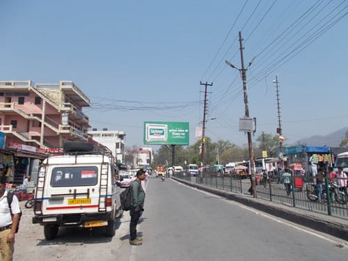
 Rishikesh does not quite belong to the category of regular Indian cities, and its junctions reflect that. This is a place where sadhus in saffron robes share the road with Israeli backpackers carrying yoga mats, where the smell of incense from riverside ashrams mingles with the diesel exhaust of the tempo travellers that ferry pilgrims toward the Char Dham route, and where every commercial transaction somehow carries a slightly spiritual coating that the city’s identity insists upon. Natraj Chowk is named after the cosmic dancing form of Lord Shiva — Nataraja, the lord of dance whose circular gesture represents the endless cycle of creation and dissolution — and in a city as thoroughly Shaivite as Rishikesh, that name is less a civic choice than a natural inevitability.
The chowk sits within Rishikesh’s busy commercial belt, serving the daily needs of a population that is itself unusually layered — permanent residents of a mid-sized Uttarakhand city, the spiritual seeking community that has been gravitating to Rishikesh since the Beatles made it internationally famous in 1968, pilgrims on their way to Badrinath, Kedarnath, Gangotri, and Yamunotri, and the adventure tourism crowd for whom the Ganga’s rapids and the surrounding Himalayan trails are the primary attraction. Natraj Chowk handles the commercial and transit needs of all of them simultaneously, which makes it more interesting than most junctions of comparable size in Indian cities.
| Detail | Information |
| Location | Natraj Chowk, Rishikesh, Dehradun District, Uttarakhand |
| Type of Junction | Commercial Urban Intersection / Pilgrimage Corridor Hub |
| Primary Road | Haridwar-Rishikesh Road (NH-58) / Rishikesh Main Road |
| Nearest Railway Station | Rishikesh Railway Station — Approx. 2–4 km |
| Nearest Airport | Jolly Grant Airport — Approx. 18–20 km |
| Key Roads Connected | NH-58, Haridwar Road, Badrinath Road, Muni Ki Reti Road |
| Distance from Haridwar | Approx. 24 km via NH-58 |
| Distance from Dehradun | Approx. 42 km |
| Distance from Badrinath | Approx. 295 km via Char Dham Route |
| Distance from Lakshman Jhula | Approx. 4–5 km |
| Governing Authority | Rishikesh Municipal Corporation, Uttarakhand PWD, NHAI |
| Nearby Landmarks | Triveni Ghat, AIIMS Rishikesh, Ram Jhula vicinity |
| Public Transport Options | UPSRTC Bus, Shared Tempo, App Cabs, Auto-Rickshaw, E-Rickshaw |
| Peak Traffic Hours | 7:00 AM – 11:00 AM and 4:00 PM – 7:30 PM (pilgrimage season peaks considerably) |
Location
Natraj Chowk is positioned within Rishikesh’s main urban commercial zone, at the junction of the Haridwar-Rishikesh highway and the connecting arterials that branch toward the Muni Ki Reti riverside belt, the Badrinath road heading northward into the Garhwal Himalayas, and the internal city roads feeding into the residential and commercial neighborhoods of this Uttarakhand pilgrimage city. The city sits where the Ganga descends from the Himalayan foothills into the plains — the precise geographic transition that makes Rishikesh sacred and the precise geographic position that makes this junction a convergence point for traffic from multiple directions simultaneously.
Directions
From Rishikesh Railway Station: Exit the station and travel toward the main commercial zone. Natraj Chowk is approximately 2 to 4 kilometres from the station, accessible in 10 to 20 minutes by auto-rickshaw or e-rickshaw through the city’s compact central road network.
From Haridwar: Travel northward along NH-58 from Haridwar heading toward the Garhwal zone. Continue approximately 24 kilometres through the scenic lower Himalayan foothills corridor. Natraj Chowk is encountered as the highway enters Rishikesh’s main urban zone. Travel time is approximately 40 to 55 minutes — considerably longer during peak pilgrimage season when this corridor becomes one of Uttarakhand’s most congested road stretches.
From Jolly Grant Airport: Exit the airport and travel northward via the connecting road heading toward Rishikesh city. About 18 to 20 kilometres, 35 to 50 minutes by app cab.
From Dehradun: Travel southeastward from Dehradun along the Rishikesh approach road. About 42 kilometres, 60 to 80 minutes including the hill descent into the Ganga valley.
From Lakshman Jhula: Head southward from the famous pedestrian suspension bridge zone toward the main city commercial belt. Natraj Chowk is approximately 4 to 5 kilometres from Lakshman Jhula, 15 to 20 minutes by auto-rickshaw through the riverside road.
Public Transport Connectivity
Rishikesh does not have metro rail and the mountain terrain makes future metro development unlikely. UPSRTC and Uttarakhand Transport Corporation buses connect Rishikesh to Haridwar, Dehradun, Uttarkashi, Joshimath, and the Char Dham pilgrimage route towns. The shared tempo service between Rishikesh and Haridwar is one of the most heavily used transport corridors in Uttarakhand — these vehicles depart throughout the day and provide the most affordable connectivity between the two pilgrimage cities. E-rickshaws have become the most characteristic urban mobility solution within Rishikesh itself, navigating the city’s increasingly restricted inner zones where regular vehicles face congestion and parking limitations. App-based cabs serve the airport journey and longer-distance needs.
Nearby Areas
Triveni Ghat: The most sacred bathing ghat in Rishikesh, where the evening Ganga aarti draws hundreds of devotees and tourists daily, is directly accessible from the Natraj Chowk zone. The aarti’s timing — just after sunset — creates a specific evening traffic pattern around the chowk as attendees arrive and depart.
AIIMS Rishikesh: The prestigious All India Institute of Medical Sciences campus established in Rishikesh is one of the most significant institutional developments this city has seen and draws patients from across Uttarakhand and the neighboring hill states, adding a substantial medical visitor population to the city’s daily transit movement.
Ram Jhula and Muni Ki Reti: The older of Rishikesh’s two famous suspension bridges and the spiritual ashram belt along the western bank are accessible from the Natraj Chowk zone via the riverside road, representing the spiritual tourism core that defines Rishikesh’s international identity.
Rajaji National Park Fringe: The forest zone of Rajaji accessible from the Rishikesh approach roads adds an ecological dimension to the broader city geography, with wildlife tourism traffic occasionally flowing through the city’s main junctions.
Frequently Asked Questions (FAQs)
Q1. Where is Natraj Chowk in Rishikesh?
In the main commercial zone of Rishikesh, on the NH-58 and Haridwar Road corridor, approximately 2 to 4 kilometres from Rishikesh Railway Station.
Q2. How far is Natraj Chowk from Haridwar?
About 24 kilometres via NH-58, taking 40 to 55 minutes — considerably longer during pilgrimage season peak traffic.
Q3. How far is Jolly Grant Airport from Natraj Chowk?
About 18 to 20 kilometres, 35 to 50 minutes by road or app cab.
Q4. What public transport is available at Natraj Chowk Rishikesh?
Shared tempos, UPSRTC buses, e-rickshaws, auto-rickshaws, and app-based cabs.
Q5. How far is Natraj Chowk from Lakshman Jhula?
About 4 to 5 kilometres via the riverside road, 15 to 20 minutes by auto-rickshaw.