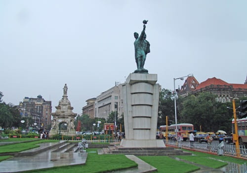
Every Indian city has junctions that carry names heavy with historical meaning, but few carry the weight of Hutatma Chowk quite as quietly and firmly as this one does. Hutatma means martyr in Marathi — one who sacrificed their life for a cause — and the chowk is named for the freedom fighters and the participants of the Samyukta Maharashtra movement who gave their lives demanding that Maharashtra be formed as a Marathi-speaking state. The Flora Fountain that stands at this junction was renamed Hutatma Chowk in 1960 when Maharashtra was finally established, and the striking statue of the martyr with the raised fist that replaced the fountain’s colonial-era iconography makes this one of the few Indian civic junctions where the naming actually changes how you experience the space.
Flora Fountain — as it is still widely called despite the official renaming — sits at the absolute geographic and institutional heart of South Mumbai’s business district. The streets radiating from it lead to the High Court, the Bombay Stock Exchange, the Reserve Bank of India, and the headquarters of the law firms, chartered accountancy practices, and financial institutions that have operated from these colonial-era buildings for generations. It is the junction at the center of the machine that runs India’s commercial capital, which means it sees a specific and highly professional daily population moving through it with the purposeful efficiency of people whose time genuinely costs money.
| Detail | Information |
| Location | Hutatma Chowk (Flora Fountain), Fort, South Mumbai, Maharashtra |
| Type of Junction | Historic Commercial and Institutional Intersection |
| Primary Road | Veer Nariman Road / Mahapalika Marg |
| Nearest Metro Station | Churchgate — Mumbai Metro Line 3 (Aqua Line) |
| Nearest Railway Station | Churchgate — Western Railway; CST — Central Railway (Approx. 1–2 km each) |
| Key Roads Connected | Veer Nariman Road, Mahapalika Marg, MG Road, Dadabhai Naoroji Road |
| Distance from CST | Approx. 1–2 km |
| Distance from Gateway of India | Approx. 2–3 km |
| Distance from Bandra | Approx. 10–12 km via sea link |
| Governing Authority | BMC, MMRDA, Maharashtra PWD |
| Nearby Landmarks | Flora Fountain, Bombay High Court, BSE Building, Elphinstone College |
| Public Transport Options | Mumbai Metro Line 3, Western Railway, BEST Bus, App Cabs |
| Peak Traffic Hours | 9:00 AM – 11:00 AM and 5:30 PM – 8:30 PM (office hours driven) |
Location
Hutatma Chowk is in the Fort area of South Mumbai, at the convergence of several important colonial-era commercial streets that have remained the addresses of Mumbai’s most prestigious financial and legal institutions since the British period. The Flora Fountain structure at the center of the roundabout — a Victorian-era stone fountain that was the original landmark before the independence movement’s renaming — continues to serve as a visual anchor for this part of South Mumbai’s heritage urban landscape. The surrounding streetscape is one of the most architecturally consistent colonial commercial zones remaining in any Indian city — Gothic Revival and Victorian buildings lining streets that have seen more Indian commercial history pass through them than almost anywhere else in the country.
Directions
From CST (Chhatrapati Shivaji Maharaj Terminus): Walk or take a very short cab from CST southward via the connecting colonial-era streets. Hutatma Chowk is barely 1 to 2 kilometres from the railway terminus — genuinely walkable in South Mumbai’s relatively pedestrian-friendly Fort area.
From Churchgate Station: Head eastward from Churchgate along Veer Nariman Road toward the Fort area. About 1 to 2 kilometres, 10 to 15 minutes on foot or 5 minutes by cab. The new Metro Line 3 Churchgate Station is even more directly connected.
From Gateway of India: Travel northwestward from the Gateway along the southern Mumbai waterfront connecting to the Fort commercial streets. About 2 to 3 kilometres, 10 to 15 minutes by cab through the heritage precinct.
From Bandra via Sea Link: Cross the Bandra-Worli Sea Link southward and continue through Worli and Prabhadevi toward South Mumbai. Total distance is approximately 10 to 12 kilometres with a travel time of 25 to 40 minutes depending on the South Mumbai traffic, which has its own specific coastal hour congestion pattern.
From Mumbai Airport: Travel southward from the airport via the Western Express Highway connecting to the city’s south-bound arterials. Total distance is approximately 25 to 28 kilometres with a travel time of 45 to 75 minutes — South Mumbai’s distance from the airport is one of the city’s most discussed logistical inconveniences.
Metro and Public Transport Connectivity
Mumbai Metro Line 3 — the Aqua Line running underground from Aarey to Cuffe Parade — has a Churchgate Station within very close proximity of Hutatma Chowk, connecting South Mumbai’s institutional core to the airport zone, Bandra Kurla Complex, and the northern suburban belt through a single underground corridor for the first time in the city’s history. This connection has been genuinely transformative for South Mumbai professionals whose daily commuting options previously depended almost entirely on the overcrowded Western and Central Railway suburban services. BEST buses serve multiple routes through the Fort area streets. Churchgate and CST suburban rail stations remain the highest daily throughput public transport access points for the broader Hutatma Chowk commercial zone.
Nearby Areas
Bombay High Court: One of India’s most important and historically significant judicial institutions, the High Court’s Gothic Revival building directly adjacent to the Hutatma Chowk zone generates a substantial daily movement of lawyers, litigants, and court officials that defines the morning character of this part of South Mumbai more than any other single institution.
Bombay Stock Exchange: The BSE building on Dalal Street — just off the streets connecting to Hutatma Chowk — houses the nerve center of India’s equity markets. The financial community concentrated in this zone gives the area a specific professional intensity that peaks during market hours and drops sharply in the afternoon in a pattern unique to financial districts globally.
Elphinstone College: One of Mumbai’s oldest and most prestigious educational institutions, Elphinstone College’s heritage building contributes an academic dimension to the Fort zone’s predominantly financial and legal character.
Kala Ghoda Arts District: The cultural precinct immediately south of Hutatma Chowk — housing the Jehangir Art Gallery, Chhatrapati Shivaji Maharaj Vastu Sangrahalaya, and the Kala Ghoda Association’s arts programming — adds a cultural and heritage tourism dimension to this part of South Mumbai that distinguishes it from purely transactional financial districts.
Frequently Asked Questions (FAQs)
Q1. Where is Hutatma Chowk in Mumbai?
In the Fort area of South Mumbai, at the Flora Fountain junction on Veer Nariman Road, approximately 1 to 2 kilometres from both Churchgate and CST railway stations.
Q2. What does Hutatma mean and why was the chowk renamed?
Hutatma means martyr in Marathi. The junction was renamed in 1960 when Maharashtra was established as a state, honouring those who sacrificed their lives in the Samyukta Maharashtra movement demanding a unified Marathi-speaking state.
Q3. Which metro station serves Hutatma Chowk Mumbai?
Churchgate Station on Mumbai Metro Line 3 (Aqua Line) is the nearest metro access point.
Q4. What financial institutions are near Hutatma Chowk?
The Bombay Stock Exchange, Reserve Bank of India, and numerous major banking and financial institution headquarters are within walking distance of this South Mumbai junction.
Q5. How far is Hutatma Chowk from Gateway of India?
About 2 to 3 kilometres via the South Mumbai heritage precinct streets, accessible in 10 to 15 minutes by cab.