 By Saurav Mehra
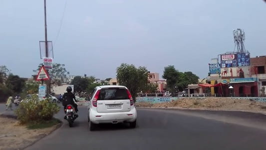
 PAP Chowk, Jalandhar is one of the most strategically important and widely referenced urban intersections in Punjab’s second-largest city, taking its name from the Punjab Armed Police — the state’s premier armed police force whose headquarters and training facilities have long been associated with this part of Jalandhar’s institutional geography. Located along one of the city’s most important arterial corridors, PAP Chowk has grown over the decades from a functional institutional junction into a genuinely significant commercial and transit hub whose daily activity reflects the scale and energy of a city that serves as one of Punjab’s most important administrative, industrial, and sporting centers.
Jalandhar’s identity is built on several distinct foundations — it is a major industrial city known for its sports goods manufacturing industry that supplies equipment to athletes globally, it is an important railway junction and highway node connecting Punjab to Delhi and the rest of India, and it carries the cultural and civic weight of a city whose history extends back to the ancient Vedic period. PAP Chowk sits within this multifaceted urban identity at a junction where the institutional character of the police establishment meets the commercial vitality of one of Jalandhar’s busiest arterial corridors. For commuters heading between the city’s residential colonies and its employment zones, for travelers using the national highway, and for the large civilian population that uses this corridor daily for shopping, education, and government services, PAP Chowk is an unavoidable and essential daily reference point.
| Detail | Information |
| Location | PAP Chowk, Jalandhar, Punjab |
| Type of Junction | Institutional and Commercial Intersection / City Arterial Hub |
| Primary Road | GT Road (NH-44) / PAP Road |
| Nearest Railway Station | Jalandhar City Railway Station — Approx. 4–6 km |
| Nearest Airport | Adampur Airport — Approx. 22–25 km |
| Key Roads Connected | GT Road (NH-44), PAP Road, Pathankot Road, Nakodar Road |
| Distance from Ludhiana | Approx. 80 km via GT Road |
| Distance from Amritsar | Approx. 80 km via GT Road |
| Distance from Delhi | Approx. 370 km via NH-44 |
| Distance from Chandigarh | Approx. 145 km via NH-44 |
| Governing Authority | Jalandhar Municipal Corporation, NHAI, Punjab PWD |
| Nearby Landmarks | Punjab Armed Police Headquarters, PAP Ground, Sports Goods Market |
| Public Transport Options | PUNBUS, PRTC Bus, City Bus, App Cabs, Auto-Rickshaw |
| Best Suited For | Jalandhar northern arterial corridor and GT Road daily traffic |
| Peak Traffic Hours | 9:00 AM – 11:30 AM and 5:00 PM – 8:30 PM |
Location of PAP Chowk
PAP Chowk is positioned along Jalandhar’s important northern arterial corridor, at the junction where GT Road (NH-44) — the historic Grand Trunk Road that has connected the length of the Indian subcontinent for centuries — meets the roads leading toward the Punjab Armed Police complex, the Pathankot highway, and the broader northwestern residential and institutional belt of the city. The Punjab Armed Police headquarters and its associated training grounds and residential colonies are the defining institutional features of this junction zone, giving it both its name and its characteristic military-administrative character. The surrounding area reflects the layering typical of Jalandhar’s urban fabric — institutional buildings, residential colonies, commercial establishments, and the constant movement of a city positioned at the crossroads of Punjab’s road network.
Directions to PAP Chowk
From Jalandhar City Railway Station: Exit the station and travel northward via the connecting arterials heading toward the GT Road corridor. Continue along GT Road heading toward the northern institutional belt. PAP Chowk is approximately 4 to 6 kilometres from the station with a travel time of 15 to 25 minutes through the moderately congested city center road network.
From Ludhiana via GT Road: Travel northeastward along GT Road (NH-44) from Ludhiana heading toward Jalandhar. Continue approximately 80 kilometres through the productive Punjab agricultural and industrial corridor. Enter Jalandhar from the southeastern direction and head toward the northern institutional zone where PAP Chowk is located. Travel time is approximately 90 to 110 minutes.
From Amritsar via GT Road: Travel southwestward from Amritsar along GT Road heading toward Jalandhar. Continue approximately 80 kilometres through the central Punjab highway corridor. Approach Jalandhar from the northwestern direction and head toward the PAP Chowk zone. Travel time is approximately 90 to 110 minutes.
From Pathankot: Travel southward from Pathankot along the Pathankot-Jalandhar Road heading toward the city. Continue approximately 100 kilometres through the Doab zone approaching Jalandhar from the northern direction. PAP Chowk is directly accessible via the northern city approach on this important intercity route.
From Chandigarh: Travel northwestward from Chandigarh along NH-44 heading toward Jalandhar. Continue approximately 145 kilometres through the Punjab highway corridor. Enter Jalandhar and head toward the PAP Chowk zone via the city’s internal arterial network. Travel time is approximately 2 to 2.5 hours.
Public Transport Connectivity
Jalandhar does not have a metro rail system and depends on a comprehensive road-based public transport network for urban and intercity mobility. PUNBUS and PRTC operate extensive services connecting Jalandhar to Ludhiana, Amritsar, Pathankot, Chandigarh, Delhi, and other Punjab and NCR destinations from Jalandhar’s main bus stand. City bus services and shared auto-rickshaws provide intra-city connectivity throughout Jalandhar’s commercial and residential zones. The city’s two railway stations — Jalandhar City and Jalandhar Cantonment — provide rail connectivity on the Delhi-Amritsar mainline with numerous express and passenger train services. App-based cab services have seen very strong adoption in Jalandhar’s urban core given the city’s relatively affluent Punjab economic character.
Road Connectivity
- GT Road (NH-44) runs northeast to southwest as Jalandhar’s primary national highway spine connecting the city to Amritsar, Ludhiana, and the entire GT Road corridor.
- Pathankot Road extends northward toward Pathankot and the Jammu highway network.
- PAP Road provides the primary institutional access road into the Punjab Armed Police complex and its associated residential colonies.
- Nakodar Road connects southeastward toward the Nakodar agricultural and industrial zone.
Nearby Areas and Neighbourhoods
Punjab Armed Police Complex: The headquarters and training facilities of the Punjab Armed Police occupy a significant institutional footprint adjacent to the chowk, housing police training academies, residential quarters for police personnel and families, and the administrative infrastructure of one of Punjab’s most important law enforcement formations.
PAP Ground: The large open ground associated with the Punjab Armed Police complex serves as a significant community recreational and gathering space in this part of Jalandhar, contributing to the junction’s civic character beyond its purely institutional identity.
Sports Goods Market Zone: Jalandhar is globally renowned as one of India’s most important sports goods manufacturing centers, and the commercial establishments associated with this industry are accessible from the PAP Chowk corridor, adding a distinctive industrial commercial dimension to the zone’s economic character.
Model Town Jalandhar: One of Jalandhar’s most prestigious planned residential localities, Model Town is accessible from the PAP Chowk zone via the connecting road network and houses the city’s professional, business, and government service elite in well-maintained residential environments.
Maqsudan and Civil Lines: Important residential and institutional localities connected to the PAP Chowk zone via the city’s arterial network, offering established civic infrastructure and the kind of mixed institutional-residential character that defines this part of northern Jalandhar.
Frequently Asked Questions (FAQs)
Q1. Where is PAP Chowk located in Jalandhar?
PAP Chowk is in Jalandhar, Punjab, on the GT Road (NH-44) corridor near the Punjab Armed Police headquarters, approximately 4 to 6 kilometres from Jalandhar City Railway Station.
Q2. What does PAP stand for in PAP Chowk Jalandhar?
PAP stands for Punjab Armed Police, the state’s premier armed police force whose headquarters and facilities gave this important Jalandhar junction its distinctive name.
Q3. How far is PAP Chowk from Amritsar?
Amritsar is approximately 80 kilometres from PAP Chowk via GT Road (NH-44), with a travel time of 90 to 110 minutes.
Q4. Is there metro connectivity at PAP Chowk Jalandhar?
Jalandhar does not have a metro system. PUNBUS, PRTC buses, city buses, auto-rickshaws, and app-based cabs provide public transport at this junction.
Q5. How far is PAP Chowk from Ludhiana?
Ludhiana is approximately 80 kilometres from PAP Chowk via GT Road, with a travel time of 90 to 110 minutes.