 By Saurav Mehra
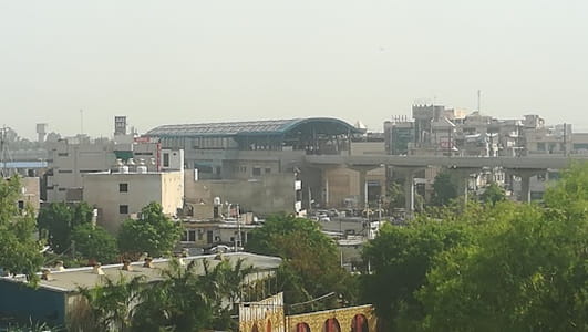
 Neelam Chowk Ajronda, Faridabad is one of the most transit-significant and rapidly evolving urban intersections in the NIT Faridabad metropolitan area, representing the precise geographic convergence of the Neelam Road commercial corridor with the Ajronda village road network and the primary arterial approaching the Neelam Ajronda Delhi Metro Station — one of the most important public transport nodes in the entire Faridabad urban system. While closely associated with the broader Neelam Chowk zone, Neelam Chowk Ajronda carries its own distinct identity rooted in the Ajronda village community that has been a permanent feature of this landscape long before NIT Faridabad’s planned sectors transformed the surrounding territory, and in the metro station that now gives this specific junction a transit significance that the broader Neelam commercial zone shares but does not exclusively own.
The addition of Ajronda to the chowk’s name reflects a very specific and important geographic distinction — the Ajronda area marks the junction point where the planned NIT sector grid meets the older organic settlement pattern of the Ajronda village community, creating the kind of urban layering that characterises the boundary zones between planned townships and the pre-existing communities they absorb over time. For daily commuters this distinction matters practically — Neelam Chowk Ajronda is the transit hub where the metro, the bus, and the road all converge most directly, making it the primary boarding and alighting point for the enormous daily commuter population of the surrounding NIT sectors heading toward Delhi and other NCR employment destinations.
| Detail | Information |
| Location | Neelam Chowk Ajronda, NIT, Faridabad, Haryana |
| Type of Junction | Metro Transit Hub / Neighbourhood Commercial Intersection |
| Primary Road | Neelam Road / Ajronda Road |
| Nearest Metro Station | Neelam Ajronda — Delhi Metro Violet Line (At Junction) |
| Key Roads Connected | Neelam Road, Ajronda Road, NIT Sector Roads, Mathura Road Connector |
| Distance from Delhi Border | Approx. 6–8 km |
| Distance from Neelam Chowk (Core) | Approx. 500 m – 1 km |
| Distance from NHPC Chowk | Approx. 2–3 km |
| Distance from Faridabad Old City | Approx. 4–5 km |
| Distance from Ballabgarh | Approx. 12–14 km |
| Governing Authority | Faridabad Municipal Corporation, DMRC, Haryana PWD |
| Nearby Landmarks | Neelam Ajronda Metro Station, Ajronda Village, NIT Commercial Belt |
| Public Transport Options | Delhi Metro Violet Line, Haryana Roadways, DTC Bus, App Cabs, Auto-Rickshaw |
| Best Suited For | Primary metro feeder hub for NIT Faridabad daily commuter population |
| Peak Transit Hours | 7:30 AM – 10:30 AM and 5:30 PM – 9:30 PM |
Location of Neelam Chowk Ajronda
Neelam Chowk Ajronda is geographically positioned in the NIT area of Faridabad at the specific junction where the Neelam Road commercial spine meets the Ajronda village road and the approach road serving the Neelam Ajronda Metro Station. This precise positioning gives the junction a trimodal transit character — road vehicles, metro rail, and local area transport all converge here — that distinguishes it from the broader Neelam Chowk commercial zone nearby. The Ajronda village community’s presence alongside the NIT township sectors creates the characteristic dual identity of this junction — part planned township commercial hub and part organic urban village transition zone — that gives Neelam Chowk Ajronda its specific geographic and social character.
Directions to Neelam Chowk Ajronda
From Delhi via Violet Line Metro: The most direct and practical approach for the majority of daily users — board the Violet Line at any Delhi metro station and travel southward to Neelam Ajronda Station. The station exits directly onto the Neelam Chowk Ajronda junction, making this a step-out-and-arrive approach that requires no additional transport.
From Delhi via Mathura Road (NH-19): Travel southward from Delhi along Mathura Road crossing the Badarpur border into Faridabad. Continue through the northern NIT sectors toward the Neelam Road zone. Neelam Chowk Ajronda is approximately 6 to 8 kilometres from the Delhi border with a travel time of 20 to 30 minutes.
From NHPC Chowk: Travel northward from NHPC Chowk along the NIT sector roads heading toward Neelam. Neelam Chowk Ajronda is approximately 2 to 3 kilometres ahead with a travel time of 10 to 15 minutes — a direct and commonly used intra-NIT approach.
From Faridabad Old City: Travel southward from the old city’s commercial core via the connecting arterials heading toward the NIT zone. Neelam Chowk Ajronda is approximately 4 to 5 kilometres from the old city with a travel time of 15 to 20 minutes through the Faridabad urban road network.
From Ballabgarh: Travel northward from Ballabgarh along Mathura Road heading toward Faridabad and Delhi. Continue through the southern Faridabad belt and into the NIT zone. Neelam Chowk Ajronda is approximately 12 to 14 kilometres from Ballabgarh with a travel time of 20 to 30 minutes.
Metro and Public Transport Connectivity
Neelam Ajronda Metro Station is the single most defining feature of Neelam Chowk Ajronda, and its positioning directly at the junction makes this one of the most immediately metro-accessible neighbourhood chowks in the entire NCR. The Violet Line from Neelam Ajronda travels northward through Faridabad’s NIT stations — NHPC Chowk, Escorts Mujesar, Sant Surdas, Mewla Maharajpur, Sector 28 — and continues all the way to Kashmere Gate via the direct Delhi metro network without requiring any interchange. This single-corridor connectivity covering the full Faridabad-to-Central Delhi span makes Neelam Ajronda Station one of the most practically valuable metro stations in the NIT belt for the enormous daily commuter population that boards here. Haryana Roadways and DTC buses serve the Mathura Road and NIT sector roads, and auto-rickshaws operate abundantly around the metro station exits throughout the day and into the night to serve the large dispersal of arriving commuters.
Road Connectivity
- Neelam Road connects northward and southward through the NIT commercial spine serving as the primary road arterial for the immediate zone.
- Ajronda Road extends into the Ajronda village community and its surrounding residential fabric.
- NIT Sector Roads provide connectivity into the residential sectors surrounding the junction from all directions.
- Mathura Road (NH-19) Connector links the junction zone to the national highway heading toward Delhi and southward to Ballabgarh.
Nearby Areas and Neighbourhoods
Ajronda Village: The original village community at the core of this junction’s Ajronda identity has been substantially absorbed into the NIT urban fabric while retaining a distinct community character, with its own local market activity, religious spaces, and the social bonds of a community that has witnessed and adapted to extraordinary urban transformation in its immediate surroundings over a compressed timeframe.
NIT Sectors 14, 15, and 16: Established residential sectors in the immediate Neelam Ajronda zone offering the full complement of NIT civic amenities — primary schools, dispensaries, local markets, and community parks — within a residential environment that has matured over decades of stable occupation and community building.
Sector 28 Faridabad: A well-established residential sector connected to Neelam Chowk Ajronda via the sector road network and the Violet Line metro at the adjacent Sector 28 Station, offering housing options within easy daily commuting distance of the Neelam Ajronda transit hub.
Crown Plaza and Commercial Developments: Larger-format retail and commercial developments accessible from the broader Neelam zone provide the NIT residential population with organised retail options that complement the neighbourhood market ecosystem of the immediate chowk area.
Industrial Areas of Faridabad: The manufacturing zones that define Faridabad’s industrial character are accessible from Neelam Chowk Ajronda via the internal road network, and the industrial workforce commuting between NIT’s residential sectors and factory employment contributes substantially to the junction’s peak-hour traffic volumes on both road and metro.
Frequently Asked Questions (FAQs)
Q1. Where is Neelam Chowk Ajronda located in Faridabad?
Neelam Chowk Ajronda is in the NIT area of Faridabad, Haryana, at the precise junction of Neelam Road and Ajronda Road where Neelam Ajronda Metro Station is located, approximately 6 to 8 kilometres from the Delhi border.
Q2. What is the difference between Neelam Chowk and Neelam Chowk Ajronda?
Neelam Chowk refers to the broader commercial junction on Neelam Road, while Neelam Chowk Ajronda specifically identifies the metro station junction where Neelam Road meets Ajronda village road — they are closely related zones approximately 500 metres to 1 kilometre apart.
Q3. Which metro station is at Neelam Chowk Ajronda?
Neelam Ajronda Metro Station on the Delhi Metro Violet Line is located directly at this junction, providing step-out access to Central Delhi without any interchange requirement.
Q4. How far is Neelam Chowk Ajronda from Delhi by metro?
Central Delhi at Kashmere Gate is accessible from Neelam Ajronda Station directly on the Violet Line in approximately 35 to 45 minutes.
Q5. Is Neelam Chowk Ajronda a good area for daily commuting to Delhi?
Yes, the direct Violet Line metro from Neelam Ajronda to Kashmere Gate makes this one of Faridabad’s best-positioned residential zones for daily Delhi commuting without road traffic dependence.